When you’re hunting, fishing, or hiking knowing where you can be the difference between safety and injury or a full freezer and an empty tag. It’s even better to know where are with respect to the landscape around you, and that’s why GPS mapping apps are so useful to hunters. They allow you see your location in relation to topography, hunt units, land boundaries, and other landscape features.
Mobile apps that display your location on topographic and satellite maps have been around for several years. These apps are one of the most important pieces of gear I take with me when I’m in the backcountry (or the front country). New features, map layers, and functional improvements can make it even easier to navigate to new places. That’s why I jumped at the opportunity to give one of the newer mapping platforms a try.
GoHunt Maps became available before the 2022 hunting season and I purchased a subscription so I could test out it’s functionality and features. After using GoHunt Maps for over four months there are some things I really like about it and some things I hope GoHunt will improve in the future. If you’re trying to decide if GoHunt maps is worth the money you’ll spend and the right mapping application for you, read on to get my thoughts.
Disclaimer: I purchased GoHunt maps at my own expense and am under no obligation to provide positive or negative feedback on the product. All opinions in this article represent my honest perspective.
My qualifications
I’m coming at this review with a unique set of qualifications. Besides being an outdoorsman that uses GPS technology regularly, I also use GPS tech and create map products professionally (I even have websites where I write about and teach geospatial concepts). Because of this I have an in-depth knowledge of GPS technology and cartography and know how these things work together in mapping apps.
I’ve used GoHunt maps for a week-long archery elk hunt, multiple weekend deer hunts, two backpacking trips, several day hikes, and some duck hunting excursions during the last four months. In all, I’ve spent more than 20 days in the field with the GoHunt maps app and much more time in the office doing e-scouting in preparation for hunts.
Over the years I’ve used and tested multiple mobile apps like GoHunt maps, so I have a good point of reference for how GoHunt maps compare to similar products on the market. If you’re interested, you can check out my reviews of Gaia GPS, OnX Hunt, and some free mobile mapping apps.
Things I like
Let’s start off with some of the apps positive components.
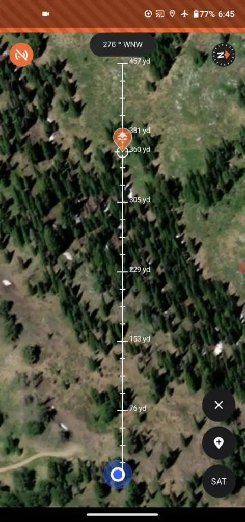
Rangefinder tool
The rangefinder tool is great and such an awesome idea! I use this all the time when hunting. This tool allows you to place a waypoint an exact distance away from your location along a bearing. When you open the rangefinder tool a line with marked yaradges will appear on the map. The line will go out from your location in the direction your phone is facing. If you ranged a bedded animal across a canyon and want to mark its location, this tool is perfect for that. This tool is also extremely useful for marking an animals last know location before a shot, so you know where to start tracking.
Yesterday I was jump shooting ducks and used this to mark locations so I could in the correct position after circling around through trees to stay out of sight. I’ve used it to mark locations of big game animals several times so that I did over or undershoot them during my stalks.
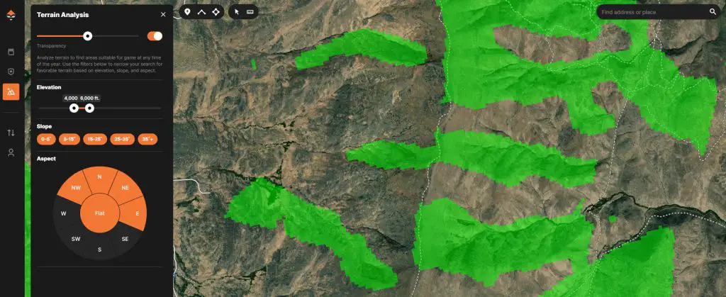
Terrain analysis tool
GoHunt’s terrain analysis tool is very useful. With this tool you can easily highlight areas on the map based on elevation, slope, and aspect. This is very useful for e-scouting and has many different applications.
Large and fast downloads
GoHunt outshines the competition in download size and speed (but see the caveat in the section about things I don’t like). You can download large areas in high resolution and download them quickly (depending on your network connection, of course).
I haven’t done a formal, timed test, but in my experience GoHunt will download a larger area faster at a higher resolution than Gaia GPS.
Downloads by state
It’s really nice to be able to download all the vector data (points, lines, and polygons – this includes hunt units, public/private land, roads, rivers, etc.) for an entire state. That way no matter where you are you always have some context for your location. Maybe you go on an impromptu scouting trip in are area without network coverage and want to make sure you stay on public land. It’s no problem if you haven’t downloaded a map before hand (you won’t have topography or satellite), you’ll still have land ownership available.
Price
GoHunt Maps cost $50/year with a GoHunt explorer membership which includes the mapping platform, gear shop points, and the GoHunt point tracker. This isn’t a great deal, but it’s on par with a $40/year Gaia GPS subscription or the $35/year Basemap subscription.
For those who are already members of GoHunt’s Insider program, this is a great deal because you don’t pay anything extra! That’s right, if you’re an insider member GoHunt Maps is part of your membership with no increased cost.
Things I don’t like
GoHunt maps has some good things going for it, but there are some pretty substantial areas where I think it falls short.
Location updating and loading issues
There are two big issues I have had with GoHunt maps. These issues are big enough that I always have maps for the same areas downloaded and available on Gaia GPS so that I don’t get left high and dry.
First, location updating is abysmal. If I turn my phone screen off, then turn it back on it takes well over a minute for the location marker to reflect my new location. This is super annoying and inconvenient when you want to check your progress on the way to a destination. It’s so bad that I usually end up switching to a different app when I need to check my progress often.
Along these same lines, my location has been marked incorrectly by up to 200 yards with GoHunt. Just yesterday, when I was duck hunting. I got GoHunt Maps started up and it showed my location to be on a road 200 yards away from where I was. Again, Gaia GPS showed me in the correct location so this is a GoHunt problem.
Second, the GoHunt Maps app never opens correctly the first time. I always have to start it. Force it to quit, then open it again. Fortunately, it loads correctly the second time I open it, but it is an annoyance. Once the app is on and running, I can turn my phone screen off and turn it back on without any problems (except for the location updating).
One other minor annoyance is that if I open the app with my location turned off it won’t take me to the last known location, or last view extent, it takes me to Michigan. Everytime. This isn’t a big deal, just annoying. Other apps store the last coordinates so you don’t have to go looking.
You might question if these problems occur because I have an older phone. That can be ruled out because I’ve used Gaia GPS, OnX Hunt, Google Maps, Google Earth, and other GPS apps on this same phone and those apps don’t have any issues. As I’ve mentioned, I often use these others apps simultaneously to make up for some of GoHunt’s shortfalls.
These are some big issues that GoHunt really needs to fix if they want to compete with other mapping apps.
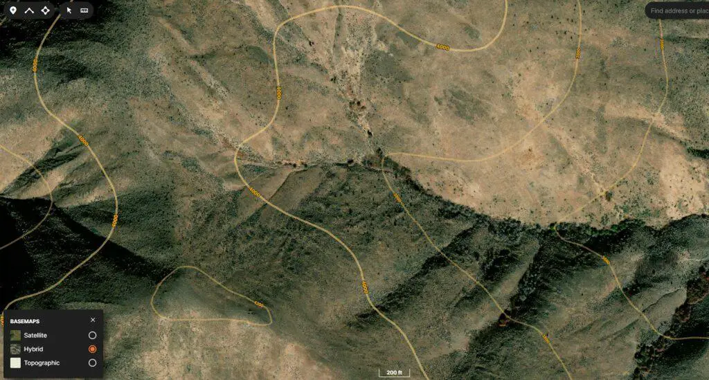
The hybrid satellite/topo layer
The hybrid satellite and topography layer (the one with contours overlaid on imagery) is the layer I use most when big game hunting. It is so useful to be able to determine aspect and slope and see imagery at the same time to identify vegetative cover.
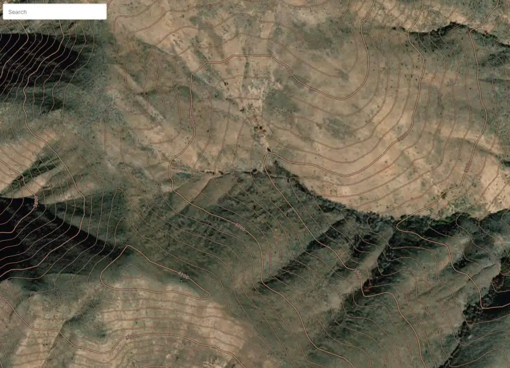
The problem with GoHunt’s hybrid layer is that the contour lines are spaced so far apart (200 feet!) that it’s very hard to determine slope and aspect. At that interval, the contours just gloss over many small draws and drainages. Also, you can’t even get the hybrid layer for offline maps. So my favorite layer, and the one I think is by far the most useful, is basically not even available with GoHunt Maps.
Now, I think they try to make up for this with 3D maps (I’ll talk about this next), but I really just prefer the hybrid layer.
3D
One of GoHunt’s big marketing points is that you can download 3D maps for offline use. This is fine. A lot of people like 3D maps. I thought I’d give it a try and found the rendering to be so slow that they were basically unusable. When using GoHunt maps on the web for e-scouting, the 3D maps are useful.
Part of my reason for putting this in the negative list is that I prefer a nice 2D hybrid layer. But even if I did prefer 3D maps, the poor performance (slow loading and rendering) wouldn’t be worth using these maps offline.
Roads and trails
I’ll start by saying that GoHunt does a good job representing roads on Forest Service land. They also represent highways and main roads well. If you’re looking for a mapping service that will give a good representation of dirt/gravel roads or ATV trails on anything that is not Forest Service land I have not found GoHunt to be very reliable. In the areas where I’ve hunted on BLM and state lands, GoHunt has not had a good representation of the road. Gaia GPS and Google Maps do better.
The same goes for trails. Good representation on Forest Service lands, poor representation everywhere else (at least from my experience).
The data are out there for GoHunt to make improvements, so hopefully they do.
Available map layers
GoHunt gets you all the important layers (satellite, topography, hunt units, land ownership, etc.) but they additional layers that can be very useful. Things like USGS topo maps, National Forest and National Parks maps, weather, snow cover, etc. are note available with GoHunt (maybe they will be in the future, who knows).
Download selection
While the size and speed of GoHunt’s map download are great, there is no way to select an area other than what is shown in your phone screen. This means you can only download in a north-south direction. If the area you’re hunting runs east-west, you still have to download multiple maps to cover it and end up downloading a lot of areas north and south of your hunting area that makes your maps take up extra memory for storage.
This is kind of funny to me, because GoHunt has a commercial all about how their maps make it so you can have fewer downloads to cover a large area. I guess this is true if you only hunt areas that run north-south.
I have tried rotating the map, before downloading, to get and east-west download. But when you click the download it forces you back to north-south orientation.
Who should use GoHunt Maps?
Becuase of my experience with location accuracy and updating I can’t recommend GoHunt maps for everyone and still have a clear conscience. You can get Gaia GPS (which I’ve used extensively without location erros) for a lower price. However, GoHunt maps may be a great option for certain groups of people.
If you’re already an Insider member there’s pretty much no reason not to use GoHunt Maps. It doesn’t cost you anything extra and it’s a decent platform. I’m sure that GoHunt will work out their bugs and continue add increased functionality. Just make sure you do some testing to be sure you can trust it when you need it.
Those that want to support a hunting-specific company may also choose this mapping platform as means to support GoHunt.
If you like the tools and features this mapping platform has to offer I would suggest giving it a trial run before you commit to it. GPS technology is something we often rely on to keep us safe and make decisions when we are in potentially dangerous situations in the backcountry. You don’t want your mapping system to be the reason for injury or complications if it can be avoided.
